
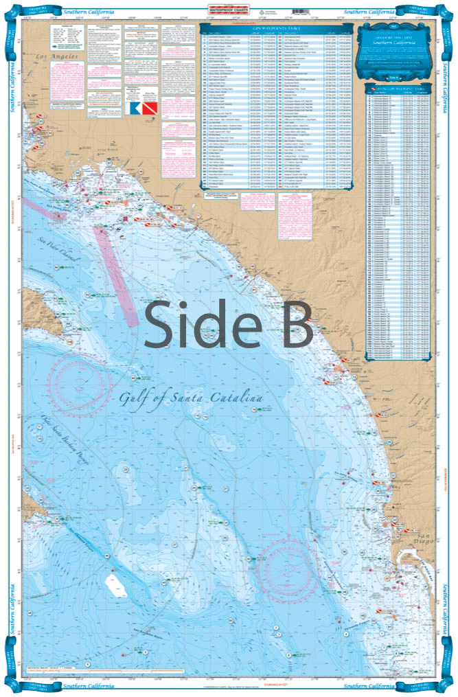

This chart covers the area south from Pt. Dume to south of Descanso, Mexico at 32 degrees north latitude and offshore 60 nautical miles. It includes a total of 444 plotted and indexed GPS positions for rocks, banks, wrecks, artificial reefs, fishing, and 171 diving locations. Added features of this chart include spot specific species and season identifiers for fish, navigation points for major harbors, high quality land detail, and much more. The combination of government charts, local knowledge, and GPS locations make this chart a great value. Whether you are a serious fisherman, or just enjoy having your line in the water, you will want this Southern California and Baja Fishing chart. This fishing chart covers the area south from Point Dume to south of Descanso, Mexico at 32 degrees north latitude and offshore 60 nautical miles. It includes a total of 444 plotted and indexed GPS positions for rocks, banks, wrecks, artificial reefs, fishing, and 171 diving locations. Added features of this marine map include spot specific species and season identifiers for fish, navigation points for major harbors, high quality land detail, and much more. The combination of NOAA charts, local knowledge, and GPS locations make this navigation chart a great value. Information from 2 NOAA charts #18740, and #18766. Nautical Chart is 25″ X 38″. WGS84 – World Mercator Datum.


Exactly what I was looking for. Quick turn around best online price shipped.
My order was filled, shipped and received within a few days. They make beautiful ways to hold my charts down while I am examining and working with them. The chartweights are attractive additions to my navigation tools. I would recommend American Nautical Services very highly.
This is a perfect nautical chart printed on heavy paper. I will be mounting it on my wall. It looks that good!
We’ve used Skipper Bob publications for the East Coast and Bahamas. They work really well and are very easy to use.