
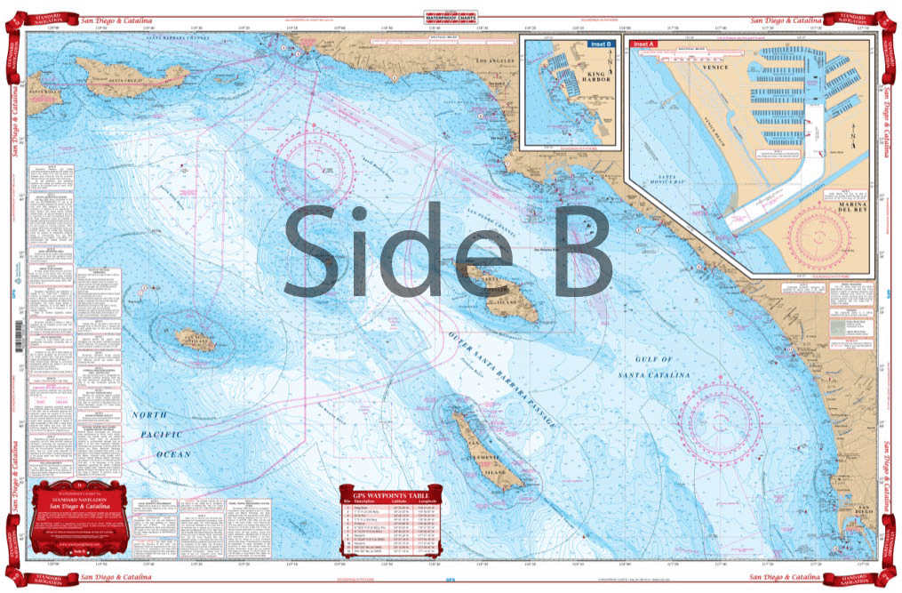
From Santa Barbara south to San Diego, this chart covers the waters offshore to San Nicholas Island with details for Santa Monica Bay and Marina Del Rey and King Harbor on one side. The reverse side details Santa Catalina Island with detailed blow ups for Isthmus Cove and Two Harbors, Avalon Bay, and Catalina Harbor. GPS Waypoints are printed directly on the chart. For journeys between San Diego and Catalina Island, this nautical map has all the detail you need. From Santa Barbara south to San Diego, this navigation chart covers the waters offshore to San Nicholas Island with details for Santa Monica Bay and Marina Del Rey and King Harbor on one side. The reverse side details Santa Catalina Island with detailed blow ups for Isthmus Cove and Two Harbors, Avalon Bay, and Catalina Harbor. GPS waypoints are printed directly on the navigation map. If you are a regular in the area, or want to remember your trip, have this navigation chart framed and display it in your home or office. Information from 3 NOAA Charts: #18740, #18744 and #18757. Nautical Chart is 25″ X 38″. WGS84 – World Mercator Datum.


Exactly what I was looking for. Quick turn around best online price shipped.
My order was filled, shipped and received within a few days. They make beautiful ways to hold my charts down while I am examining and working with them. The chartweights are attractive additions to my navigation tools. I would recommend American Nautical Services very highly.
This is a perfect nautical chart printed on heavy paper. I will be mounting it on my wall. It looks that good!
We’ve used Skipper Bob publications for the East Coast and Bahamas. They work really well and are very easy to use.