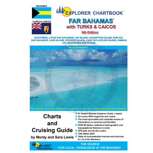
This new 9th edition of the Explorer Chartbook Far Bahamas brings you the most up-to-date charts and cruising guide information for the islands stretching from Eleuthera to the Turks and Caicos. Every chart and each settlement’s Need-to-Know Info has been revised and updated so that you can confidently explore the outer reaches of the Bahamian/TCI archipelago.
FEATURES:
-
Covers Eleuthera, Little San Salvador, Cat Island, Conception Island, Rum Cay, San Salvador, Long Island, Crooked Island, Long Cay, Acklins Island, Samana Cay, Mayaguana, Inagua and Turks & Caicos
-
Tide Tables 2024
-
91 cruiser-friendly Explorer Charts
-
Overview Planning Chart of the Bahamas
-
(8) Small Scale charts
-
(11) Medium Scale charts
-
(49) Large Scale charts
-
(21) Closeup charts
Chart Detail:
-
Notes on "Joins page..."
-
Chart page overlaps
-
Extensive hydrographic and topographical features to scale, plus road maps for land travel
-
Updated variation on compass roses
-
New and corrected hydrographic data
-
Shaded depth contours
-
1/10-minute grid and border scales
-
On-scene GPS waypoints and routes
-
Printed on water- and tear-resistant material
-
The most up-to-date and complete source of information on services and facilities (Need-to-Know Info)
-
Latest table of recommended marinas and services for all of the Bahamas
Special Articles including:
-
Far Bahamas History and Description
-
Customs and Immigration
-
Emergency Medical Evacuation
-
Flight Services
-
Bahamas National Parks
-
Waypoint List
-
Father Jerome
-
Cruising the Bight of Acklins
-
Negotiating the Columbus Bay Reef
-
The Samana Debate
-
Turks and Caicos History and Description
-
Turks and Caicos Help Menu